
Файл:Qing Dynasty 1820.png

Үзлэгийн хэмжээ : 800 × 593 пиксел Бусад зургын нягтрал: 320 × 237 пиксел | 640 × 475 пиксел | 910 × 675 пиксел.
Эх файл (910 × 675 пиксел, файлын хэмжээ: 398 КБ, MIME төрөл: image/png)

|
This historical map image could be re-created using vector graphics as an SVG file. This has several advantages; see Commons:Media for cleanup for more information. If an SVG form of this image is available, please upload it and afterwards replace this template with
{{vector version available|new image name}}.
It is recommended to name the SVG file “Qing Dynasty 1820.svg”—then the template Vector version available (or Vva) does not need the new image name parameter. |
Товч агуулга
| Тайлбар |
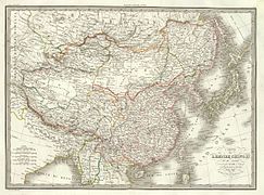
English: Map of the Qing Dynasty in 1820, representing its stablized territory from 1790-1839. (Includes provincial boundaries and the boundaries of modern China for reference.) Provinces in yellow, military governorates and protectorates in light yellow, tributary states in orange.
Adapted from File:ROC_PRC_comparison_eng.jpg and information complied from:
中文(简体):大清嘉庆二十五年疆域图。约合1790-1839稳定时期疆域。
中文(繁體):大清嘉慶廿五年疆域圖。約合1790-1839穩定時期疆域。
日本語: 大清の嘉慶25年の疆域の図。
Tiếng Việt: Đại Thanh bản đồ (1820).
Français : Carte du Grand Empire des Qing la 25e année Jiaqing du règne de l'empereur Qing Jiaqing (1820). Cette carte inclus les frontières provinciales et les frontières de la chine contemporaine pour référence. Les provinces sont en jaune, les gouvernorats et protectorats militaires en jaune claire, les états tributaires en orange. |
| Огноо | |
| Эх үүсвэр | Энэ миний бүтээл |
| Зохиогч | Pryaltonian |
| Other versions | File:Qing_1820_CHGIS.png |
Лиценз
I, the copyright holder of this work, hereby publish it under the following licenses:
Энэ файл нь Creative Commons Attribution-Share Alike 3.0 Unported лицензтэй байна.
- Та чөлөөтэй:
- хуваалцах – бүтээлийг хуулбарлах, түгээх, дамжуулах
- ремикс хийх – ажлыг тохируулах
- Дараах нөхцөлд:
- хамаарал – Та зохих кредитийг өгч, лицензийн холбоосыг өгч, өөрчлөлт оруулсан эсэхийг зааж өгөх ёстой. Та үүнийг ямар ч боломжийн аргаар хийж болно, гэхдээ лиценз олгогч таныг эсвэл таны хэрэглээг зөвшөөрөхгүй.
- адилхан хуваалцах – Хэрэв та материалыг дахин найруулах, хувиргах эсвэл бүтээх юм бол same or compatible license-ийн дагуу өөрийн хувь нэмрийг эх хувьтай нь түгээх ёстой.

|
Энэхүү баримт бичгийг GNU Free Documentation License, Хувилбарын нөхцлийн дагуу хуулах, түгээх болон/эсвэл өөрчлөх зөвшөөрөл олгосон. 1.2 эсвэл Чөлөөт програм хангамжийн сангаас нийтэлсэн дараагийн хувилбар; Инвариант хэсэггүй, нүүрэн талын текстгүй, арын хавтастай текстгүй. Лицензийн хуулбарыг GNU Free Documentation License гэсэн хэсэгт оруулсан болно. |
Та өөрийн хүссэн лицензээ сонгож болно.
See also
-
 1820 Map of Asia by Daniel Lizars
 -
 1851 map of Tibet, Mongolia and Manchuria by John Tallis
 -
 1844 map of China and Japan by John Nicaragua Dower
 -
 1833 French map of China and Japan
 -
 1832 French map of China and Japan
 -
 1836 French map of China and Japan
_-_Geographicus_-_Asia-lizars-1820.jpg)

.jpg)
.jpg)
.jpg)
.jpg)
Файлын түүх
Огноо/цаг дээр дарж тухайн үеийнх нь файлын байдлыг харна уу.
| Огноо/Цаг | Жижиг зураг | Хэмжээ | Хэрэглэгч | Тайлбар | |
|---|---|---|---|---|---|
| одоогийн | 05:15, 17 Тавдугаар сар 2014 | | 910 × 675 (398 КБ) | Tenohira | fix |
| 04:32, 17 Тавдугаар сар 2014 |  | 910 × 675 (401 КБ) | Benlisquare | rev: per the guideline page at Commons:Overwriting existing files, you should be creating a fork file, not overwriting this existing one | |
| 00:48, 17 Тавдугаар сар 2014 |  | 910 × 675 (394 КБ) | Tenohira | remove "nine-dotted line" https://en.wikipedia.org/wiki/File_talk:Qing_Dynasty_1820.png | |
| 23:59, 16 Тавдугаар сар 2014 |  | 910 × 675 (372 КБ) | Tenohira | original | |
| 21:52, 19 Арванхоёрдугаар сар 2012 |  | 910 × 675 (401 КБ) | Pryaltonian~commonswiki | Adjusted map to be more in line with contemporary-Qing maps, with references also from late-Qing and Republican China. | |
| 15:35, 22 Есдүгээр сар 2011 |  | 910 × 675 (380 КБ) | Pryaltonian~commonswiki | Only southern Palawan was part of the Borneo and then Sulu sultanates, until Spanish annexation of Sulu in 1851. | |
| 15:10, 21 Есдүгээр сар 2011 |  | 910 × 675 (380 КБ) | Pryaltonian~commonswiki | Modified to distinguish between provinces, military governorates, and protectorates. Tributary states also added. | |
| 03:48, 22 Зургаадугаар сар 2010 |  | 910 × 675 (355 КБ) | Benlisquare | Revert - redraw the map yourself. MS Paint overlaying of a corner is an eyesore. Illogical to have the title repeated twice. | |
| 21:46, 21 Зургаадугаар сар 2010 |  | 910 × 675 (386 КБ) | Hisacw | rv to NPOVify: the status on certain outlier islands (e.g. Sakhalin) is not explicitly defined, c.f. the map [http://go-passport.grolier.com/map?id=mh00032&pid=go] | |
| 05:59, 20 Зургаадугаар сар 2010 |  | 910 × 675 (355 КБ) | Benlisquare | Reverted to version as of 19:58, 27 September 2008 |
Холбоос
Файлын хэрэглээ (бүх төсөл)
Дараах бусад вики энэ файлыг ашигладаг:
- als.wikipedia.org дахь хэрэглээ
- an.wikipedia.org дахь хэрэглээ
- ar.wikipedia.org дахь хэрэглээ
- azb.wikipedia.org дахь хэрэглээ
- az.wikipedia.org дахь хэрэглээ
- bat-smg.wikipedia.org дахь хэрэглээ
- ba.wikipedia.org дахь хэрэглээ
- be-tarask.wikipedia.org дахь хэрэглээ
- be.wikipedia.org дахь хэрэглээ
- bg.wikipedia.org дахь хэрэглээ
- cs.wikipedia.org дахь хэрэглээ
- da.wikipedia.org дахь хэрэглээ
- de.wikipedia.org дахь хэрэглээ
- en.wikipedia.org дахь хэрэглээ
- Qing dynasty
- History of Taiwan
- Inner Mongolia
- Administrative divisions of China
- Zhili
- Talk:History of the administrative divisions of China before 1912
- Tannu Uriankhai
- User:Pryaltonian
- Portal:Taiwan
- Taiwan under Qing rule
- User:Eumolpus214
- Talk:Qing dynasty/Archive 3
- History of Tuva
- Senkaku Islands dispute
- Tributary system of China
- Talk:Chinese civilization/Archive 26
- Talk:Qing dynasty/Archive 5
- Qing dynasty in Inner Asia
- Timeline of the Qing dynasty
- Timeline of Yunnan-Guizhou
- Talk:History of Xinjiang/Archive 1
- Administration of territory in dynastic China
- Government of the Qing dynasty
- User:SilverStar54/Administrative divisions of China
- Wikipedia:Reference desk/Archives/Humanities/2023 July 15
- User:Falcaorib/China
- Administrative divisions of the Qing dynasty
- es.wikipedia.org дахь хэрэглээ
Энэ файлын дэлхийн хэрэглээг харах.